
Download the full article: Read the article
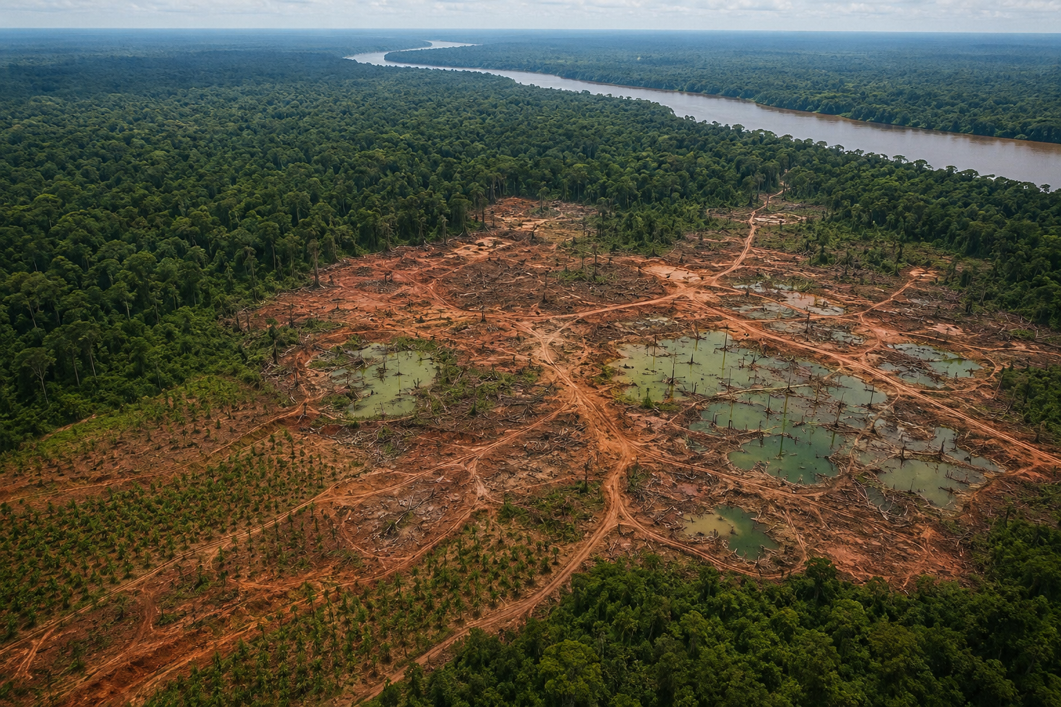
Reading the photograph: from above, the tropical forest still looks like a green sea. Yet at the centre of the frame, the land opens like a wound: bare reddish earth, murky greenish pools filled with dead tree stumps, dirt roads branching like veins, and rows of young shoots along the edges. In the distance, a great river flows, seemingly unaware that downstream its waters are becoming shallower and cloudier.
Reading the Wound from Above
There is no fire in this photograph, no chainsaw and no smoke. That is precisely what makes it frightening: it captures the aftermath—after trees have been felled, soil stripped and water driven out of the swamp. Similar scenes can be found in Sumatra, Kalimantan, Papua and many other tropical regions. At first glance, it looks like “empty land ready for development”. What we are seeing, however, is a peatland ecosystem being slowly dismantled. That dismantling begins the chain of disasters knocking at our doors again in 2026.
What a Swamp Really Is
Peat forms over thousands of years from plant remains that die in waterlogged conditions and do not fully decompose. These rare ecosystems cover only around 3% of the Earth’s land, yet hold approximately 30% of its soil-carbon stocks. Indonesia has the world’s largest tropical peatland area, around 13.4 million hectares, storing more than 57 gigatonnes of carbon. When wet, peat acts as the Earth’s sponge: absorbing water in the rainy season and releasing it slowly in the dry season, keeping rivers flowing and forests alive. Remember this metaphor, because every disaster described below begins with one thing: a sponge drained dry.
The Water That Leaves
Peat destruction almost always starts the same way: drainage canals are dug to dry the swamp for planting or extraction. Once the water leaves, peat changes from sponge to fuel. Dry soil begins to decompose, releasing carbon, then compacts and subsides. During the early years of drainage, the ground can fall by 1–2 metres, continuing to subside by 3–5 centimetres a year thereafter. The murky pools at the photograph’s centre are not signs of healthy peat. They are signs of a damaged sponge: water is no longer held in the soil but collects over its wounds. Kalimantan’s recurring forest and land fires are a drama born of our failure to protect the land: peat damage and canal drainage increase fire risk.
2026: The Smoke Returns
This is not an archive photograph. In August 2026, Kalimantan’s skies turned grey once more; smoke had blanketed parts of West Kalimantan since July. Air quality in six provinces—Riau, South Sumatra, Central Kalimantan, West Kalimantan, Jambi and surrounding areas—fell into the unhealthy category. The numbers became human lives: the Health Ministry recorded 3,405,489 people directly affected by fire-related smoke in Kalimantan. West Kalimantan recorded the highest figure, with 165,747 cases of acute respiratory infection. In Pontianak, cases rose by 5–10% within just a week of the smoke appearing. Behind those numbers are sore throats, stinging eyes, breathless nights and hospitals filled with children’s coughing. A disaster we once considered “seasonal” has become a terrifying calendar: peatland fires had already erupted in early 2026.
The Classroom Taken Away
The quietest chapter of this disaster is written in schools. As smoke thickened, West Kalimantan’s Education and Culture Office moved general, vocational and special secondary schools online for four days from 11 August 2026. Anxious parents in Pontianak called for school closures because air quality was so poor. The House of Representatives also asked the government to consider temporary school holidays. Yet “closing schools” is not the same as “keeping children safe”. They lose learning time, play and a childhood that should unfold outdoors, not behind tightly shut windows. When they must still go out—to help their parents, buy medicine or walk to a shop—their developing lungs inhale the same particles driving the surge in respiratory infections. Each smoke season cuts away another piece of their future: healthy lungs, the right to clean air and an education repeatedly interrupted. Today’s haze steals two things from West Kalimantan’s children at once: breath and learning.
The Drought Already before Us
Smoke often obscures another disaster, slower but no less destructive: the loss of clean water. Damaged peat-swamp forests mean lost water sources; a torn sponge can no longer store reserves for the dry season. West Kalimantan is already feeling the consequences. The Kapuas River’s flow is shrinking and its depth falling sharply, hampering clean-water distribution in Kubu Raya. In Pontianak, reduced upstream flow allows seawater to intrude, turning water that should sustain residents brackish. In Sungai Malaya Village, the government had to distribute 5,000 litres of clean water because of drought.
Add one more variable: a warming Earth. Dry, burning peat releases carbon that raises temperatures; higher temperatures prolong dry seasons. This year, BMKG forecast a very strong El Niño that would extend West Kalimantan’s dry season until October 2026. The cycle is now complete: swamps are drained → carbon is released → temperatures rise → drought lasts longer → great rivers such as the Kapuas struggle with falling water → residents lose clean water → dry land burns more easily. What was once a scientific warning is now the lived experience of people queuing with water containers.
A Legacy of Wounds
The ecological damage left in West Kalimantan is not confined to one season. Fires in deep peat can cause permanent ecological damage, lowering communities’ quality of life and economic prospects for decades. Around 2.79 million hectares of Kalimantan’s peatlands have been degraded, becoming increasingly vulnerable to fire year after year.
Subsiding land will end up permanently flooded. Lost swamp forests will not return with their orangutans, hornbills and endemic fish. Carbon released today will continue warming the Earth long after the flames are extinguished. West Kalimantan’s children, now studying online behind masks, will inherit shallower rivers, hotter air and poorer soil than we inherited. This is ecological disaster at its cruellest: its victims are not yet born when we make the decisions that cause it.
Shoots at the Wound’s Edge
Yet the photograph records more than wounds. Along its left and lower edges are neat rows of young shoots, suggesting that recovery is still being attempted through rewetting, water-compatible cultivation known as paludiculture, and revegetation. Recovery, however, requires more than planting. Canals must be blocked, governance enforced and economic decisions changed so that land meant to remain wet is no longer drained. Destroying peat takes only one dry season; restoring it takes decades—and some wounds will never heal.
Closing: A Photograph as a Mirror
We often call floods, droughts and haze “natural disasters”. This photograph, together with the 2026 smoke season, challenges that description. There is nothing natural about 3.4 million people affected by smoke, 165,000 West Kalimantan residents suffering acute respiratory infections, children moved to online schooling, or the Kapuas becoming shallower and subject to seawater intrusion. These are human-made disasters, arising from decisions to drain swamps and clear forests.
From the air, the wound looks small: a pale patch within an expanse of green. From the ground, however, that wound determines the air our children breathe, the water we drink and which river will run dry first. Ultimately, this photograph is a mirror. It shows not only what we have done to the Earth, but what we are doing to ourselves—and to generations that have not yet had the chance to refuse our legacy.